Maesgwyn Ganol, Guilsfield, Welshpool, Powys
Guide Price: £1,390,000Share:
Description
- • Agricultural
Maesgwyn Ganol comprises of an attractive residential and commercial agricultural holding near Guilsfield, that provides substantial family accommodation, a range of both traditional and more modern farm buildings set in approximately 92.22 acres (37.32 hectares) that is available as a whole or up to six conveniently split lots.
Lot 1:
Farmhouse, Farm Buildings & 13.44 Acres
(5.44 Hectares)
FARMHOUSE
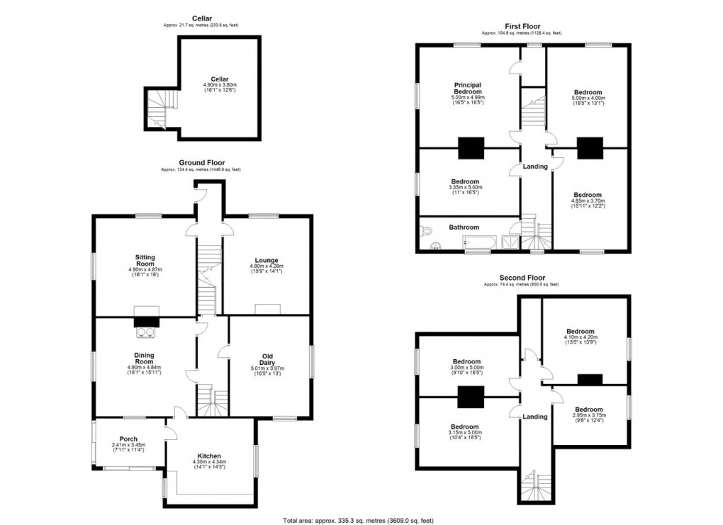
An attractive and extensive farmhouse providing approximately 3,600 square feet of living space, situated to the west of the farmyard including 8 bedrooms in need of some extensive modernisation and upgrading works.
The versatile and well-proportioned property provides ample family accommodation, comprising a spacious porch and kitchen with fitted cupboards, dining room with an oil-fired Rayburn, sitting room and lounge.
On the first floor there is a principal bedroom with a walk-in wardrobe and three further bedrooms, a family bathroom with tiled walls and suite comprising a shower bath, W.C and wash basin. Stairs lead to a third floor and landing with access to a further four rooms that offer renovation opportunities.
All rooms benefit from large, double-glazed windows enjoying views over the surrounding garden and the countryside beyond.
FARM BUILDINGS
Maesgwyn Ganol benefits from a range of traditional brick barns that have potential for conversion into further accommodation (subject to planning). Beyond these barns are a range of more modern agricultural buildings which include three livestock sheds. Supporting this is a slurry storage tank system and a silage pit.
1. General Purpose Building - Steel portal framed building (6 bay) with concrete floor and part concrete wall and Yorkshire boarding sides (26.98m x 19.94m)
2. Garage - Concrete walled garage with open front and corrugated tin roof (5.98m x 4.10m)
3. Cattle Building - Steel portal framed building (6 bay) with concrete flooring and adjoining cubicle housing shed. Open fronted with corrugated tin roof and sides (29.01 x 15.96m)
4. Silage Pit - Concrete flooring and sides (23.07m x 13.77m)
5. Traditional Barns - Brick-built construction under slated roofs. Concrete flooring throughout, currently used for storage and in need of repair (14.38m x 11.23m & 15.00m x 11.02m)
6. Traditional Barns - Brick-built construction under slated roofs. Concrete flooring throughout, currently used for storage and in need of repair (15.96m x 5.49m & 9.41m x 8.79m)
7. Loose Housing - Brick walled shed with open front and enclosed rear (13.98m x 8.70m)
8. Slurry Tower
The Measurements above have been taken from Edozo and are approximate and for indicative purposes only.
LAND
Lot 1: 11.78 Acres (4.77 Hectares)
Two parcels that extend to approximately 11.78 acres (4.77 hectares) of predominately grade 3b agricultural land currently laid to grassland, situated at approximately 530 feet to 580 feet above sea level, comprising of slowly permeable seasonally wet acid loamy and clayey soils.
The land is served by borehole and natural water and is accessed via an unclassified council-maintained highway in serval places.
Lot 2: 14.66 Acres (5.93 Hectares)
A single ring-fenced parcel extending to approximately 14.66 acres (5.93 hectares) of grade 3b agricultural land currently laid to grassland, situated at approximately 500 feet to 550 feet above sea level, comprising of slowly permeable seasonally wet acid loamy and clayey soils.
The land is served by natural water and is accessed via an unclassified council-maintained highway in serval places.
Lot 3: 11.11 Acres (4.50 Hectares)
A single ring-fenced parcel extending to approximately 11.11 acres (4.50 hectares) of grade 3a, 3b and 4, agricultural land currently laid to grassland, situated at approximately 580 feet to 725 feet above sea level, comprising predominately of freely draining slightly acid loamy soils' but also incorporating slowly permeable seasonally wet acid loamy and clayey soils.
The land is served by natural water and is accessed via hardcore track from an unclassified council-maintained highway.
Lot 4: 35.91 Acres (14.53 Hectares)
A ring-fenced block comprising of 3 field parcels extending in all to approximately 35.91 acres (14.53 hectares) of predominately grade 3b agricultural land currently laid to grassland, situated at approximately 550 feet to 850 feet above sea level, of slowly permeable seasonally wet acid loamy and clayey soils.
The land is served by natural water, but also benefits from a borehole, situated in Lot 1, that pushes water up to several water tanks. Prospective purchasers should be aware that the purchaser of Lot 1 will have the right to remove the borehole water supply to Lot 4.
The land is accessed via two right of ways, as indicated ‘A’ via Lot 1 and ‘B’ a track via Lot 5 on the attached plan.
Lot 5: 9.15 Acres (3.70 Hectares)
A ring-fenced block of broadleaf woodland known as ‘Bank Wood’, extending to approximately 9.15 acres (3.70 hectares) that incorporates an area of rough pasture, amounting to approximately 1.19 acres. The woodland is accessed via an unclassified council-maintained highway in two locations.
Lot 6: 7.95 Acres (3.22 Hectares)
A ring-fenced block comprising of 3 field parcels extending in all to approximately 7.95 acres (3.22 hectares) of predominately grade 3b agricultural land currently laid to grassland, situated at approximately 575 feet to 700 feet above sea level, comprising predominately slowly permeable seasonally wet acid loamy and clayey soils but also incorporating freely draining slightly acid loamy soils.
The land is served by natural water and is accessed via an unclassified council-maintained highway in two locations.
BOUNDARY RESPONSIBILITIES
Any purchaser shall be deemed to have full knowledge of all boundaries and neither the Vendor nor the Vendors Agents are responsible for defining the boundaries or ownership thereof.
BASIC PAYMENT SCHEME
The land is registered with Rural Payments Wales; entitlements are available by separate negotiation.
TENURE
We have been informed that the property is freehold. Vacant possession will be given on completion. The property is not registered with Land Registry.
SPORTING & MINERAL RIGHTS
We understand that the rights are in hand and will be transferred with the sale.
EASEMENTS & WAYLEAVES
The property is sold subject to and with the benefit of all existing wayleaves, easements, and rights of way, public and private whether specifically mentioned or not.
SERVICES
Mains electricity, private water and private drainage.
N.B. The services, appliances and flues have not been tested, and no warranty is provided with regard to their condition.
DIRECTIONS
What3words: ///smuggled.rifled.shut
Postcode: SY21 9DG
COUNCIL TAX
Band G
Local Authority: Powys 1 (Montgomeryshire)
METHOD OF SALE
The property is being offered for sale by Informal Tender, with the following Price Guides:
Lot 1:
Farmhouse, Farm buildings & 13.44 Acres
(5.44 Hectares) of Agricultural Land
£675,000
Lot 2:
14.66 Acres (5.93 Hectares) of Agricultural Land
£165,000
Lot 3:
11.11 Acres (4.50 Hectares) of Agricultural Land
£165,000
Lot 4:
35.91 Acres (14.53 Hectares) of Agricultural Land
£325,000
Lot 5:
9.15 Acres (3.70 Hectares) of Broadleaf Woodland Known as ‘Bank Wood’
£60,000
Lot 6:
7.95 Acres (3.22 Hectares) of Agricultural Land
£75,000
As a Whole:
Farmhouse, Farm Buildings & 92.22 Acres
(37.32 Hectares)
£1,390,000
Offers are to be submitted in the prescribed format along with all documentation to Tom Davies BSc (Hons) MRICS FAAV by 12 Noon on Friday 30th May 2025.
VIEWING & NEGOTIATIONS
Accompanied by prior arrangement with the selling agents. All interested parties are respectfully requested to communicate directly with the Selling Agents.
HEALTH AND SAFETY
The agents advise all prospective purchasers when viewing the property to take due care. No viewing is to take place of any of the buildings except when accompanied by a representative of the agent.
MONEY LAUNDERING REGULATIONS
On putting forward an offer to purchase you will be required to produce adequate identification to prove your identity within the terms of the Money Laundering Regulations (MLR 2017 came into force 26th June 2017). Appropriate examples: Passport or Photographic Driving Licence and a recent
Utility Bill.
MORTGAGE SERVICES
Should you decide to use the services of the Mortgage Advice Bureau, you should know that we would expect to receive a referral fee of £250.00 from them for recommending you to them.
Flood Risk (Per NRW)
Flooding from Rivers: Very Low Risk
Flooding from Sea: Very Low Risk
Flooding from Surface Water and small watercourse: High Risk
Coastal Erosion: No Risk
Broadband and Mobile Signal
https://www.ofcom.org.uk/phones-and-broadband/coverage-and-speeds/ofcom-checker
Council Tax Band: G
Floorplan
EPC
Market your property
with Morris Marshall & Poole
Book a market appraisal for your property today. Our virtual options are still available if you prefer.